| The "Grand Pacific Drive" is a scenic tourist drive stretching south
from Sydney's Royal National Park (the second oldest in the world) to
Nowra, a 2-3 hour drive hugging the coast. Non-stop, that is. Stopping
to smell the roses, so to speak, can stretch it out to days. The Drive
was created as an attempt to boost tourism in the region when the Sea
Cliff Bridge was reopened in December 2005. The bridge replaced a
section of road that was closed in 2003 due to regular rock falls.
Parts of the bypassed section of road can still be seen, wedged between
the bridge and the cliff face, although a good sized chunk appears to
have vanished, either due to a landslide or human action. We only
travelled part of the Drive, Stanwell Park to Wollongong (along the
Lawrence Hargrave Drive). |
|
|
|
|
Stanwell Park from Bald Hill
Image © David Powell, 2007 |
Bald Hill
Image © David Powell, 2007 | Sea Cliff Bridge from Bald Hill
Image © David Powell, 2007 |
|
|
Lawrence Hargrave Memorial
Image © David Powell, 2007
|
First stop on the Lawrence Hargrave Drive was Bald Hill at Stanwell
Park. Bald Hill is one of the most popular lookouts along the Illawarra
coastline and it's not hard to see why with clear views up and down the
coast. Spectacular views. Views of the mountains meeting the sea.
Further south the mountains retreat from the coast, but in the north
there's little or no coastal plateau and the drop down to the sea is
amongst the most dramatic in the country. There's barely enough room
for the road, rail line and the tiny (and very narrow!) hamlets
scattered along the northern Illawarra coast and precariously perched
on the cliff edge. Some of the hamlets consisting of only the main road
and a single parallel side street - there's no room for anything more.
At one spot the mountains drop directly to the sea below, hence the
need for the Sea Cliff Bridge, which is really an elevated roadway,
partly over the rock shelf at the sea's edge and partly over the sea
itself.
Apart from being a mecca for hang glider enthusiasts and its great
views, Bald Hill is also famous for having played a vital role in the
early years of aviation. It was there from the 1880's into the early
1900's that Lawrence Hargrave experimented with flight. In 1894, 9
years before Orville & Wright, Hargrave flew in his box kite. He is
credited with pioneering work on curved aerofoils, essential for
controlled heavier-than-air flight, rotary air plane engines and he
even designed a seaplane.
|
|
|
Sea Cliff Bridge from the air
Image © RTA, 2007
|
Heading south from Stanwell Park is the hamlet of Coalcliff .. a beach,
railway station, one side street of houses and a coke work in the
hills. About 1.5km south of Coalcliff is Clifton, which is much the
same sans the beach, railway station and coke works. Doesn't leave
much, I guess - two streets, a handful of houses, oh, and a public
telephone. The names of those hamlets should give you an idea of the
local geography.☺ All existing on a very narrow and sloping strip of
land wedged between the mountain escarpment and the sea cliffs. Still,
with the bridge back up there's a bit of a building boom going on. Not
that there's much land, more a matter of renovation.
Covering 665 metres of the road between Coalcliff and Clifton is the
Sea Cliff Bridge. Certainly not the largest & longest in the world
(not even in Australia), far from it, but impressive nonetheless,
especially with much of it perched on the shoreline or over the ocean
(even more at high tide). There's a walkway stretching the full length
of the bridge, for the more energetically inclined. There's some
limited parking at the southern end (on the shoulder of the road) and
at the northern end you can find street parking along Paterson Road
(Coalcliff's side street), if you're lucky. While you can see almost
all of the bridge from Bald Hill, it's a fair way in the distance it's
often hazy with sea spray. Up close you can only see part of the bridge
at any one time, unless maybe at low tide from the tip of the rock
shelf offshore at Coalcliff. The nice promo shots in the tourist mags
and the Drive's website all seem to have been taken
offshore from a helicopter - the angle of the shots is just not
possible whilst standing on terra firma. Still, we managed to see the
bridge from both ends and walk partway along the walkway, from both
ends. The more dramatic close-up views are from the southern end,
however sun glare is a problem from that direction. The best option is
to get a long distance view from Bald Hill (zooming with a decent
camera or binoculars is a good idea) and then close up of the different
sections.
|
|
|
|
|
Sea Cliff Bridge, North view
Image © David Powell, 2007 |
View north from Coalcliff
Image © David Powell, 2007 | Sea Cliff Bridge, South view
Image © David Powell, 2007 |
|
|
View north from Cape Horn, Scarborough
Image © David Powell, 2007
|
|
|
View south from Cape Horn, Scarborough
Image © David Powell, 2007
|
The next village heading south was Scarborough, much the same as
Coalcliff and Clifton, with a railway station, primary school and a
small beach. Strangely, Scarborough Beach isn't in Scarborough but in
the next hamlet south, Wombarra. Scarborough is perched on Cape Horn
and there're great views up and down the coast, the latter overlooking
a small beach. Looking south you can see all the way to Wollongong and
beyond. To the north you can see the headland that Clifton is perched
on and beyond that Bald Hill. Coalcliff and the Bridge are sadly hidden
from view. Still, looking north you can see how steep the slope is and
you have to be amazed at how they can fit in a road, rail line and a
hamlet in such a restricted space. Still, people are if nothing else,
inventive and necessity is the mother of invention. For some odd reason
the prime land in Scarborough, right at the cliff's edge, was taken up
by
a school. A high rate of ball loss I daresay.☺
|
Heading on south is Wombarra and Coledale, now effectively grown into
one village. Wombarra-Coledale makes a change in the scenery - at this
point the mountains and the sea begin to diverge with a coastal plateau
maybe a kilometre wide at this point tho' there's still a coastal
cliff, maybe 50-100 metres high. Further south the level area drops and
widens considerably into the city of Wollongong, the third largest in
the state, and the rich farming region of the Illawarra. At Coledale we
stopped at the Mike Dwyer Park, opposite the hospital with views east
across the ocean and, more immediately, a rock shelf stretching out
several 100 metres at low tide (at high tide it's entirely covered and
only a small, narrow beach separates land and sea) and what appear to
be the remaints of early 20th century sewage outfalls - all that's left
now are rows of concrete pillars stretching out to the end of the rock
shelf. Looking south is Coledale beach in the foreground and in the
distance the view stretches as far as Shellharbour and Bass Point,
south of Wollongong. A short distance south we stopped at Coledale
Beach and had a walk around the rock shelf. The tide was going out but
there was still some impressive waves crashing onto the outer edge of
the shelf. On the other side of the shelf you could see all the
different rock layers in the cliff including a few small coal seams
(the productive seams are higher up in the mountains). An amazing
variety of vegetation clings to the side of the cliffs. Even a few
small caves. Despite being exposed, Scarborough Beach is fairly placid,
especially given the rough surf dozens of metres away at the rock
shelf. The waves all seem to break well short of the beach, no doubt a
continuation of the rock shelf below sea level.
|
|
|
|
Rocks from Mike Dwyer Reserve, Coledale
Image © David Powell, 2007 |
Coledale Beach from Mike Dwyer Reserve
Image © David Powell, 2007 | Rock platform, north of Coledale Beach
Image © David Powell, 2007 |
|
|
|
|
Rock platform, north of Coledale Beach
Image © David Powell, 2007 |
Rock platform, north of Coledale Beach
Image © David Powell, 2007 | Cynthia .. who splashed me?
Image © David Powell, 2007 |
Next stop was Brickyard Point at Austinmer. Arguably Austinmer is the
northern-most suburb of Wollongong. From Austinmer on south to the
heart of the 'Gong the built-up area is contiguous. Still, Austinmer
manages to retain something of a coastal village atmosphere with some
of the trappings of suburbia. Naturally enuf, more great views. Didn't
get to see the northern view, but from the map it looked to give the
view up to Coledale and beyond. Looking south was Tuckerman Park and a
beach that presumably has some name but not in any of the maps I have
and beyond that a series of headlands jutting out in succession. Add to
that a collection of impressive Norfolk Pine's. There's a rather tatty
looking and run-down motel on the site, but I'm sure the developers
will discover that place soon.
|
|
|
|
South view, Brickyard Point, Austinmer
Image © David Powell, 2007 |
Rock shelf, Brickyard Point, Austinmer
Image © David Powell, 2007 | View from carpark, Brickyard Point
Image © David Powell, 2007 |
We ended the trip at Wollongong where we had lunch at a wonderful
little cafe on a side street off the Crown Street Mall, aptly named
"Hideaway Cafe" since it does a good job of it. The decor could have
done with a bit of attention, but the food was simply delicious and the
place had a nice atmosphere. They even have live music two evenings a
week. A little bit of Europe. France or Italy maybe. Restaurant guides
list it as a mid-range eatery, so not overpriced and not cheap &
nasty. Personally I very recommend the place. Oh, details ... 81 Church
Street, 02-4229-6186.☺
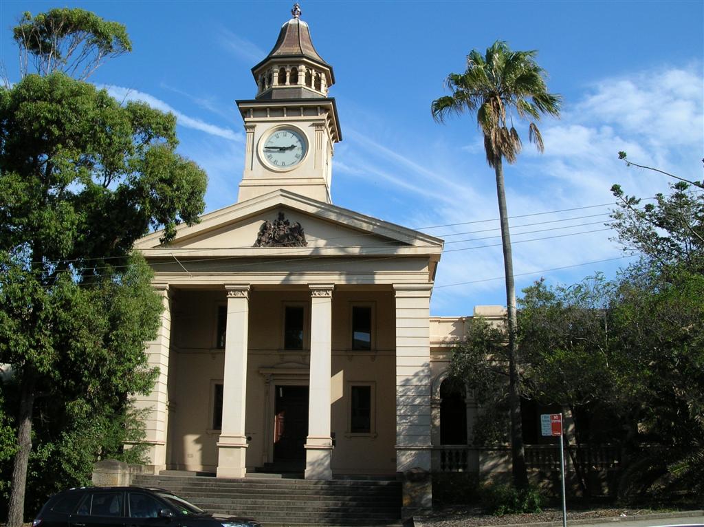
After lunch we did a bit of shopping and had a look at some old
buildings in the city centre. Saw the St Michael's Cathedral, Allowrie
Terrace and the city courthouse. The present St Michael's was built in
1858-1859 (replacing a previous building), built in Gothic style with
the traditional cross plan. The church has a steep slate roof, a
steeple and is built using large sandstone blocks. Allowrie Terrace is
an unknown, other than that it was built before 1859. The present court
house was built in 1885.
|
|
|
|
St Michael's Cathedral, Wollongong
Image © David Powell, 2007 |
Allowrie Terrace, Wollongong
Image © David Powell, 2007 | Courthouse, Wollongong
Image © David Powell, 2007 |
|