|
|
| Little Lake entrance, Warilla Image © David Powell, 2007 |

Tuesday
Headed off Tuesday morning. First stop was 90 minutes down the coast to drop in and spend a day with my folks at their holiday weekender at Warilla, a stone's throw north of Shellharbour. Did a few odd jobs about the place including a computer repair while Cynthia took off to the local swimming pool with my mum for a few hours. Reunited, we went for a walk for an hour or two along the coast to Barrack Point, midway 'tween Warilla and Shellharbour. First along a stretch of beach where there were
|
|
| Barrack Point Image © David Powell, 2007 |

Off to a local club for dinner with my folks and a friend of the family I'd not seen in, hmmm, almost 20 years. Tho' at the time she had a different husband. Well that's the way it goes I guess. A few rounds of cards with my folks and then to the resort we'd booked in for the night. The world is full of coincidences - we ended up with the same room we got the last time we stayed there, a few months ago. Yeah, I know, all motel rooms tend to look the same, but they do have numbers. Wednesday
|


Next stop was Crooked Creek Winery. On an earlier visit to the region we'd had some of their wine at a restaurant. Being suitably impressed, we made a point of finding the winery and buying a box of bottles. Not cheap, but their range is most palatable (not that I'm a wine expert). There're on the Pacific Highway, just inland from Gerringong. Only been in the business since 2001, it's already the region's largest winery and has won a swag of medals from regional to national. There's a restaurant and in February/March they even allow visitors to help stomp their grapes, the old fashioned way. If you're partial to a drop or two of quality vino, do drop in!
The road south then winds through gently rolling hills before reaching the town of Berry, about 10km inland. A little town, best known for its boutique shopping. Even the St Vincent's store is a boutique! Visited a few shops, spent a small fortune and had lunch at a café on the main street. Haven't seen the old courthouse before and since we had some time, stopped to have a look at that. Built around 1891, along the 'traditional' rural courthouses of the time, it continued in use until 1988. It has been restored and formal gardens (complete with fountains and ponds) established in the grounds. It's now used for weddings, exhibitions, concerts and the like. Inspired by the drought no doubt, one of the formal gardens has been redesigned for minimal water usage. Late afternoon we arrived at Vincentia, on the shores of scenic Jervis Bay, there to spent the rest of the day and the night at friend's weekender. The rest of the day was fairly quiet .. chatting, playing cards and so forth. Been there several times before. A lovely atmosphere - it backs onto the bush, which was quite green, despite the drought, but then, it is only a block away from the coast. Lots of birds - a non-stop chorus, fortunately not too loud. |


Thursday
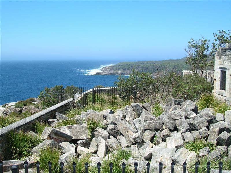
In addition to the main building there were also the remains of the stables, kitchens and the toilets. Strangely enough, the last were the best well preserved of all the ruins on the site, even tho' they were perched rather close to the cliff edge. Fortunately there's a stone fence along the cliff edge in the vicinity of the lighthouse, otherwise going for a midnight nature call might pose a few dangers, especially if one'd been celebrating beforehand! Walked around some of the trails to get some great views. No fences, rails or any other safety feature to be seen, apart from a fence around the ruins itself (and that's probably more to keep people off the ruins). So definitely a case of watching one's step - carefully! Especially with the stiff winds! An amusing side note .. the middle of nowhere and I had to queue up for the toilet! The lighthouse has had a rather interesting history. Its location was chosen by a bureaucrat-cum-architect based not on where it should have gone by maritime needs but rather where it was easier to build - the light wasn't even visible from the northern approach (from Sydney) to the bay and during it's operation around 23 ships were lost in the area. The old story - common sense versus economics, with the former loosing out. It operated for 28 years before a replacement was built on the north head of the bay, a location much preferred by the real experts - those whose livelihoods were based at sea. Even after it was abandoned, the lighthouse continued to be a navigational hazard, especially on moonlit nights when the stone of the tower would shine, so around 1920 the tower was demolished with explosives. Time and the elements have sadly continued that process. There were also more than a few deaths on the site while the lighthouse operated, some from disease, others from falls over the cliff. |


|
|
|
|||
| Lighthouse, east view Image © David Powell, 2007 |
Lighthouse, south-west view Image © David Powell, 2007 | Old toilet block & Moes Rock Image © David Powell, 2007 |


|
|
|
|||
| View south over ruins (Moes Rock) Image © David Powell, 2007 |
Snapper Point & Governor Head Image © David Powell, 2007 | Cynthia, below lighthouse Image © David Powell, 2007 |


Lunch was at the service station at Wandandian. The bacon and egg burgers were positively delicious!
|
|
| Point Upright, from Depot Beach Image © David Powell, 2007 |

|
|
| Depot Beach Image © David Powell, 2007 |

Headed east from Mogo to Broulee, on the coast. From there we spent nearly two hours travelling up the coast to Bateman's Bay (normally a 10-15 minute drive), stopping at all the possible lookouts and scenic views on the coast t'ween Broulee and Bateman's Bay. And there're quite a few of them! Broulee Beach was long, at least a km. Not really a surf haven - to the south it's protected by Broulee Island and to the north by Mossy Point. But great for paddling or just boosting the vitamin D levels. High vegetation covered dunes hide all sign of civilisation from the beach. The southern tip of the beach is especially well protected which lead to Broulee being established as a port as early as 1830's, tho' by 1850 it had been eclipsed and little, if any, evidence remains on the ground of that history today. Today it's a holiday haven. To the north of Broulee Beach is Mossy Point, the next stop. Lots of rocks just offshore. At low tide you can walk out on a rock shelf to a small island at the tip of the point. Some quite remarkable rock formations, weathered by wind and surf over the millennia. A few rocky coves on the southern side of the point, quite unsheltered from the southerly winds, as well as some neat trails thru' the thick but stunted pine trees covering the southern side of the point. Walking the narrow trails, with the sound of the wind blowing thru' the trees it was kinda magical. Almost as if you were in some fantasy world. And then there're the views! Melville Point is not all that spectacular in itself, but it offers wonderful views north along Barlings Beach and Long Nose Point (honest!) and south of Mossy Point and Broulee beyond. In spring it offers great views of migrating whales.
|


Burrawarra Point is just barely visible from Broulee and Mossy Point. A hour hike from the car park will take you to the lookout at the tip of the point. We forwent that and checked out the views near the car park of Guerilla Bay, Jimmies Island and Rosedale, to the north. Didn't see
|
|
| View south, from Rosedale Point Image © David Powell, 2007 |
|
|
| Guerilla Bay, from Burrawarra Point Image © David Powell, 2007 |

Continuing north we stopped at Malua Bay and its famous beach (yup, there were surfers there and the surf was up). Apart from the beach, Malua Bay's also popular amongst divers. Then Lilli Pilli Point, overlooking Lilli Pilli Beach. Yup, yet another beach. It's said that NSW has more beaches on its coastline than anywhere else in the world. Big ones, secluded ones, tiny ones, surf ones. A beach for everyone.
With daylight running out, the last stop on the coast crawl was Observation Point at Batehaven. Strangely, the car park is all fenced in and you have a bit of a walk to go around the fences to get to the original trail system that takes you around the point. Almost as if they don't want people going there. But the views are spectacular. North into Bateman's Bay and south along rugged coastline down to at least Lilli Pilli. East are a group of islands just offshore, one big enuf to have its own forest and a large cave just above sea level. That's Snapper Island.
Finally back to Bateman's Bay and dinner. Lots of seafood cafés and fast food joints in the town. Quite a few pizza shops. But if you're after something other than seafood and pizzas, but not a restaurant, your choices are very limited. Friday We were going to go on a river cruise up the Clyde River to Nelligen, but the timing just didn't work out. So plan B instead. First stop was "Treasures from the Deep", an opal and shell museum-shop. It wasn't big, but it was packed to the rafters with shells, exoskeletons and preserved marine specimens. Probably millions of the things. As well as shells there were also a small collection of crystals and mineral specimens. As for the opals, the owner is a retired opal miner from Lightning Ridge, so he definitely knows his opals. We browsed thru' the opal collection looking for something to match an opal ring Cynthia already had. It was an expensive ring, so it turned out to be an expensive necklace - which had an opal the guy had mined himself. Got a few mineral specimens for myself.
|


Then it was the long trip back home to Sydney. Just north of Bateman's
Bay we stopped off at Holmes Lookout. Reminded me of the Sherlock
Holmes joke about the missing tent. Eventually we found the lookout,
after driving several kilometres past, and then only because someone
else had found it. A nice view of Bateman's Bay and the Clyde River,
tho' partially obscured by the trees. Presumably when the
Further on to Nelligen. An old town founded in 1854 on the banks of the Clyde River, upstream from Bateman's Bay. First a timber town, then gold was found in the region and the town had a second life. But when that ran out, the town slowly died away. Before its last gasp, it had a third life, this time based on tourism. The area is a haven for river fishing and boating - a wide and deep river - deep enuf that back in its heyday steamships travelled upriver to the town. There's not much left now. Between bushfires and the ravages of time, only a few of the old buildings remain. Today the town consists of a few homes, several cafes, two churches (one abandoned) and a big caravan park. Peaceful, quiet and great views. The best views we found were uphill from the site of the old school (burnt down now). From the empty block (now a park) you got a great view upstream. The little park by the river was positively delightful. St Joseph's (1896), Mechanics Institute (1903), The Steampacket Inn (1905) and the Post Office (1900) - the latter two are now B&B's. There's also the old court house (1893), now the local Anglican church. |

|
|
|
|||
| Steampacket Hotel, Nelligen Image © David Powell, 2007 |
Courthouse Church, Nelligen Image © David Powell, 2007 | Clyde River from school site, Nelligen Image © David Powell, 2007 |


|


|
|
|
|||
| View from Warden Head, Ulladulla Image © David Powell, 2007 |
Ulladulla Harbour from Ulladulla Head Image © David Powell, 2007 | Beach & Ulladulla Head Image © David Powell, 2007 |


Heading north again we reached Nowra. Instead of continuing along the highway through Wollongong and onto Sydney, we took the longer, scenic route via Kangaroo Valley. In Kangaroo Valley we saw the first real signs of the drought - it was a lot dryer than normal. Usually it's quite lush in the valley. Having been there several times recently, we didn't stop but continued onto Moss Vale. Lots of history and heritage there, but that'll be another trip. On we continued to Berrima.
|


|
|
|
|||
| Breens Inn (1840), Berrima Image © David Powell, 2007 |
Courthouse (1838), Berrima Image © David Powell, 2007 | Governors' House, Gaol, Berrima Image © David Powell, 2007 |


Lots of lovely old buildings with nothing new-looking to disturb the harmony. Only a few pubs and cafés were open by the time we got there. Had a delicious dinner, complete with live music, at the Surveyor General Inn, built in 1834 and the oldest continually licensed pub in the
|
|
| The First Bank (1836), Berrima Image © David Powell, 2007 |

|
|
| Gaol (1839), Berrima Image © David Powell, 2007 |

|


Bombo Headland Quarry Geological Site: http://www.sydneywater.com.au/whoweare/OurHeritageAssets/_item_view.cfm?hi=4572730
Bombo Headlands: http://www.kiama.com.au/attractions/default.htm
Bombo Headland Landcare Group: http://www.landcareillawarra.org.au/bwWebsite/followon.asp?PageID=1800
Crooked River Wines: http://www.crookedriverwines.com/
Berry Courthouse, NSW Government State Heritage Listings: http://www.heritage.nsw.gov.au/07_subnav_02map.cfm
The Ill-Fated Cape St George Lighthouse: http://www.lighthouse.net.au/LIGHTS/NSW/Index%20NSW.htm
Depot Beach: http://www.clydecoast.com.au/depotbeach/index.html
Historic Mogo: http://www.southcoast.com.au/mogo/
Old Mogo Town Gold Rush Theme Park: http://www.oldmogotown.com.au/
South Coast - Broulee: http://www.visitnsw.com.au/Destination.aspx?DProductID=9001683
Walkabout - Broulee: http://walkabout.com.au/locations/NSWBroulee.shtml
Tomakin (Burrawarra Point): http://mysite.verizon.net/~brenin/tomakin.html
Batemans Bay, Wikipedia Entry: http://en.wikipedia.org/wiki/Batemans_Bay,_New_South_Wales
Bateman's Bay: http://www.southcoast.com.au/batemansbay/
Eurobodalla - Bateman's Bay: http://www.naturecoast-tourism.com.au/batemans.htm
Treasures From the Deep: http://www.wickedweekends.com.au/areas/nsw/south_coast/batemans_bay/opal/shell_museum.htm
Nelligen: http://www.nelligen.com/
Nelligen on the Clyde: http://www.southcoast.com.au/nelligen/index.html
Ulladulla: http://www.ulladulla.info/
Warden Head Lighthouse: http://www.lighthouse.net.au/liGhTS/NSW/Warden%20Head/Warden%20Head.htm
Ulladulla Lighthouse: http://www.ulladulla.info/attractions/lighthouse.html
Southern Highlands of NSW - Berrima: http://www.highlandsnsw.com.au/towns/berrima.html
Walkabout - Berrima: http://walkabout.com.au/locations/NSWBerrima.shtml
Historic Berrima: http://berrimavillage.com.au/index.html
Berrima Courthouse: http://www.berrimacourthouse.org.au/